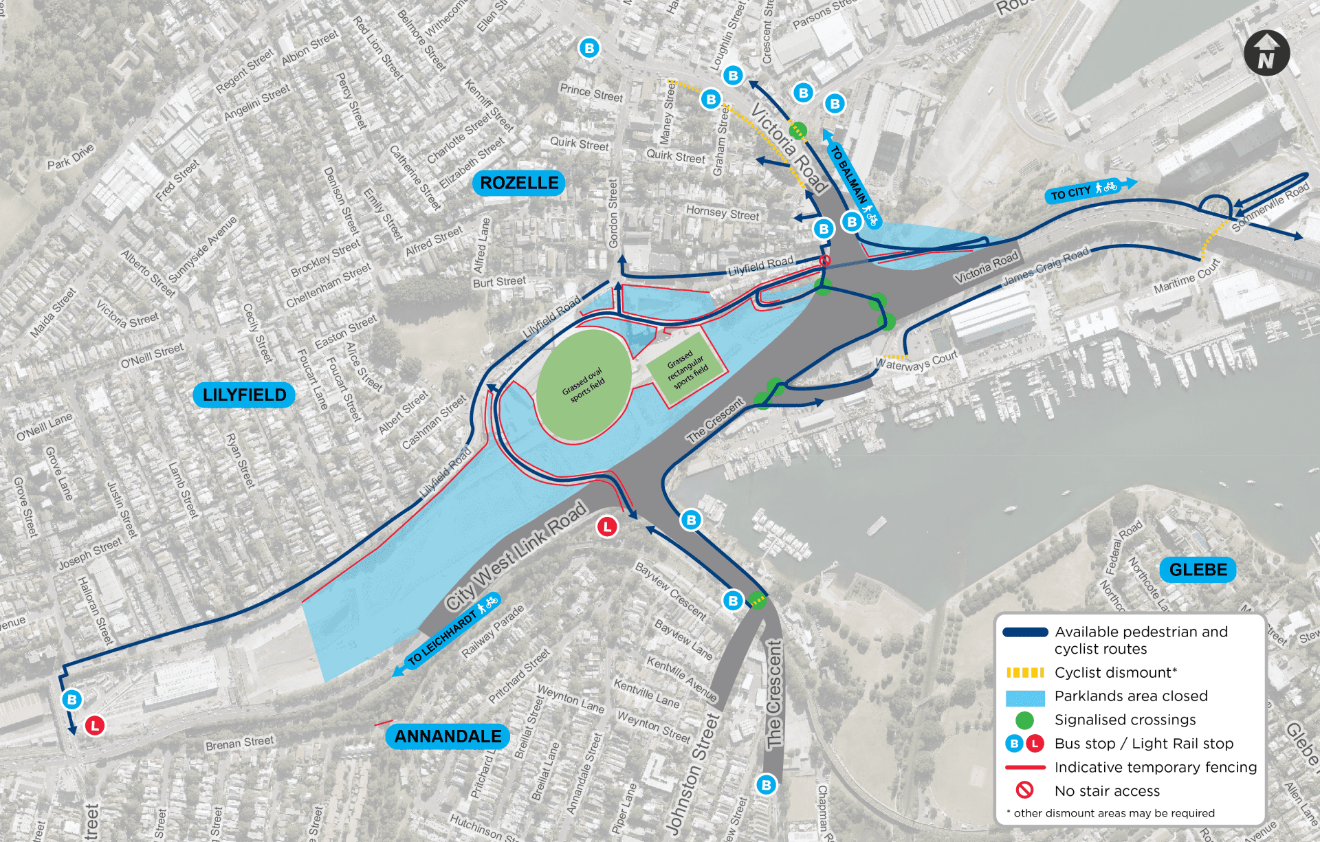
Opening of the sporting fields, pedestrian and cycling paths from the Green Link Bridge
We are pleased to announce the next stage of the re-opening of the Parklands and shared pedestrian and cycling paths.
The two sports fields within the Parklands, as well as the pedestrian and cycling paths connecting the Rozelle Bay Light Rail stop to the Victoria Road underpass, reopened to the community on Thursday 28 March 2024 at 5pm (see wayfinding map below).
The stairs on the city side of the Victoria Road bridge are also now open.
The areas have passed the required safety clearances to ensure they are safe to open to the community for their use. As we are still continuing to work, for the safety of the community and our workers you will see some temporary fencing in place around the Parklands.
We ask that you please refrain from entering the fenced off areas until we advise that it is safe to do so. The map below shows the location of the sports fields and shared paths reopened, as well as indicative positions of the temporary fencing.
Pedestrian and cyclist changes
While work continues, sections of the Parklands' pedestrian and cycling paths will remain closed. Sections will continue to open in stages throughout April and we will advise you of any changes to access as they occur.
Please observe signs and temporary fencing in place and for your safety do not enter closed areas.
As new sections re-open, signs will be placed at key intersections to inform the public of the changes and new routes to help you navigate the area.
Pedestrians and cyclists will be able to access the Rozelle Parklands via Gordon Street, Denison Street and the Green Link Bridge from the Rozelle Bay Light Rail stop. These entry points provide access to the Parklands' pedestrian and cycling paths, as well as the Victoria Road bypass to access the city via Anzac Bridge.
Parklands Update - 22 January
Work will start at Rozelle Parklands on Tuesday, 23 January to safely remove and dispose of all asbestos-contaminated mulch from across the site.
Transport’s contractor, John Holland CPB Joint Venture (JHCPB), will this week establish key work site facilities, erect further fencing and signage and create special vehicle and machinery access to key locations.
Background
Rozelle Parklands has been fenced off and closed to the public after the discovery of recycled garden mulch used in landscaping was found to contain traces of bonded asbestos.
JHCPB is ready to remove mulch in all areas that have been identified by the Environment Protection Authority (EPA), in addition to a number of other publicly accessible areas.
Plans to remediate other areas outside the Parklands which have returned positive results to targeted sampling, including garden beds adjacent to the road and paths around the junction of the Anzac Bridge, Victoria Road and City West Link are underway.
In total, Transport for NSW identified 17 positive samples of bonded asbestos.
What is next?
Work will begin at the eastern Victoria Road end of the park and progress westwards to allow for the staged re-opening of the site to the community.
Contaminated mulch will be removed from garden beds before being transported from the site in covered trucks to an authorised disposal facility.
Up to 30 workers will be on site over coming weeks to methodically work through the park to ensure full compliance with the EPA’s 29 February deadline to remove affected material at the Parklands site.
Once the site is cleared, new organic mulch will be spread with an EPA Accredited Site Auditor signing-off to ensure it meets all guidelines. The mulch removal will be conducted in a way to minimise damage to tens of thousands of already established plants, turfed areas, and the shared user paths. This adds additional time to the completion of the work on site, with a staged approach allowing the first sections of the park to open gradually towards the end of March.
Walking and cycling
Walking and bicycle paths through the park will be closed during the clean-up work.
The community are asked to revert to using pedestrian footpaths and bicycle lanes that were in place during the construction of the Rozelle Interchange Project, prior to the opening of the Parklands. Detour maps will be provided in construction notifications.
What about safety?
JHCPB is engaging with both the EPA and SafeWork NSW to ensure all safety protocols are followed during the work.
Our priority is safety and the efficient completion of the project, with necessary safeguards in place to protect the community.
Monitoring around the site for airborne particles will continue throughout the clean-up work. Ongoing tests have not identified anything outside of normal parameters at this time.
NSW Health advises the risk of illness for anyone who has come in contact with this material is low.
The EPA’s investigation into the source of contamination in the mulch remains ongoing.
When will Rozelle Parklands reopen?
Rozelle Parklands is scheduled to reopen in stages.
The mulch removal will be conducted in a way to minimise damage to tens of thousands of already established plants, turfed areas, and the shared user paths.
This adds additional time to the completion of the work on site, with a staged approach allowing the first sections of the park to open gradually towards the end of March.
We will keep you updated on the project’s progress, so you stay across the latest information.
Where do I go for more information?
If you have any questions regarding the safety action plan, please call 1800 660 248.
Transport remains committed to creating a safer environment and understands the inconvenience this project may cause. We appreciate your patience as we work to reopen Rozelle Parklands again for the community to enjoy.
Rozelle Interchange connects the M4 to the Anzac Bridge and the M8 to City West Link and Victoria Road. Delays are expected on approach to the Anzac Bridge citybound from 7am to 9am in the morning peak.
Travelling to the City
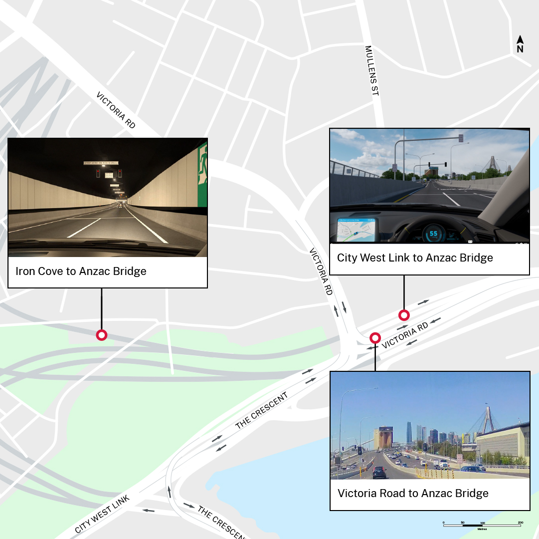
- From Victoria Road: Keep to the right on Iron Cove Bridge to access the toll-free tunnel. Once inside the tunnel, use the left two lanes to connect directly to Anzac Bridge. No tolls apply. Take a virtual drive.
- From M4 East: Continue past the Wattle Street exit and use the left two lanes to continue along the M4 tunnel and connect directly to Anzac Bridge. A maximum toll of $11.11 per journey applies for passenger vehicles. Take a virtual drive.
- From M8: Keep to the far left in the M8 tunnel and take the exit on the left to City West Link. When exiting the tunnel to City West Link, use the left two lanes for the City. A maximum toll of $11.11 per journey applies for passenger vehicles. Take a virtual drive.
Travelling from the City
- To Victoria Road: Keep to the far left on Anzac Bridge and take the first exit on the left to the toll-free tunnel connecting directly to Iron Cove Bridge and Victoria Road. Take a virtual drive.
- To M4 East: Keep to the left on Anzac Bridge to connect directly the M4 tunnel. A maximum toll of $11.11 per journey applies for passenger vehicles. Take a virtual drive.
- To M8: Use the right two lanes on Anzac Bridge to continue onto City West Link. Keep to the right after The Crescent for the M8 tunnel. A maximum toll of $11.11 per journey applies for passenger vehicles. Take a virtual drive.
View more virtual journeys using Rozelle Interchange here.
Tolls
Rozelle Interchange is part of WestConnex. All WestConnex tolls are calculated using a ‘flag fall’ of $1.57 at the point of entry and then $0.58 per kilometre. After 16.4 kilometres of continuous travel, a toll cap comes into effect. For passenger vehicles, tolls will be capped at a maximum amount of $11.11 per journey. For heavy vehicles, the maximum toll cap is $33.32 per journey.
Watch this Rozelle Interchange flyover video below to learn more.
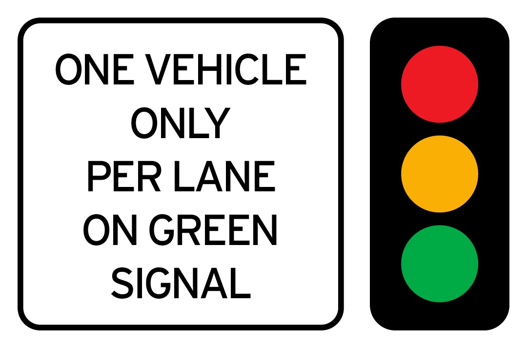
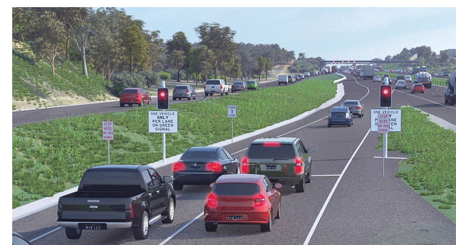
Ramp Signals
Ramp signals are operating at key locations on approach to Anzac Bridge;
- Victoria Road to Anzac Bridge
- City West Link to Anzac Bridge
Ramp signals control the rate of vehicles exiting the Interchange on approach to Anzac Bridge. The signals can be set for different metering rates to improve traffic flow and minimise congestion. They make merging safer and easier and reduce the risk of drivers having to brake suddenly.
The signals allow one vehicle per lane to enter when a green light is displayed. The green signal allows the first vehicle in each lane to join the Anzac Bridge. When the signal is red, you must stop behind the ‘Stop’ line.
Ramp meters are activated during peak traffic periods or when there is heavy traffic congestion.
What are ramp meters and how do they work?
Ramp meters use traffic signals at motorway on-ramps to control the rate of vehicles entering the motorway. The signals can be set for different metering rates to improve freeway flow and minimise congestion. They make merging safer and easier and reduce the risk of drivers having to brake suddenly.
They control the flow of vehicles entering the motorway by allowing one vehicle per lane to enter when a green light is displayed. The green signal allows the first vehicle in each lane to join the motorway. When the signal is red, you must stop behind the ‘Stop’ line.
Ramp meters are activated during peak traffic periods or when the motorway experiences heavy congestion. They work by monitoring traffic conditions to ensure a steady and controlled flow of vehicles, reducing congestion and making it easier to merge onto the motorway.
For information about driving safely in tunnels, visit https://www.linkt.com.au/help/using-toll-roads/tips-for-driving-in-tunnels/sydney
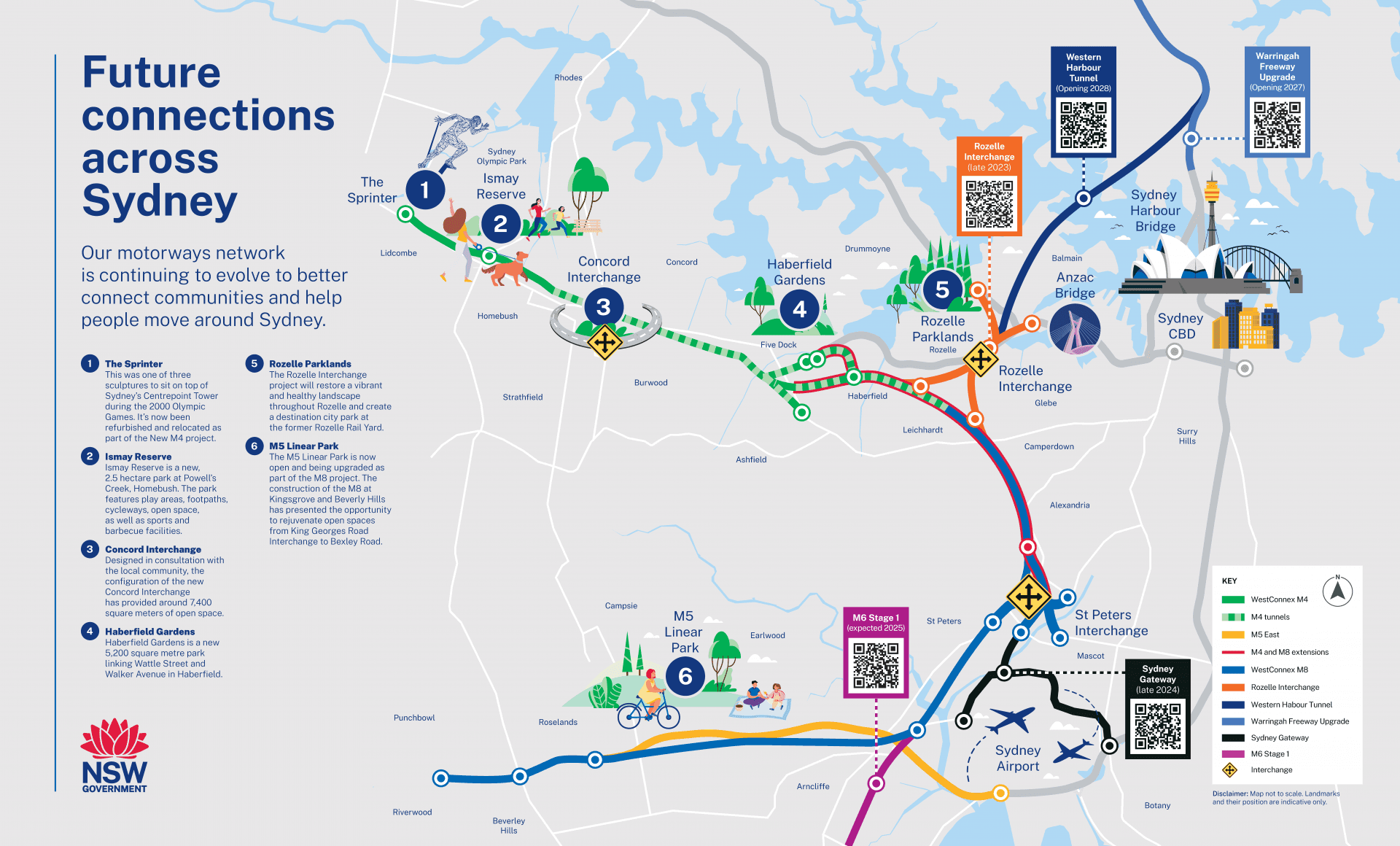
Future Connections
Our motorways network is continuing to evolve to better connect communities and help people move around Sydney.
Download our Future Connections Across Sydney map here.
The owner and operator of Rozelle Interchange is Transurban.
For more information about Rozelle Interchange, visit https://caportal.com.au/tfnsw/wcxri
Look out for updates on the Rozelle Interchange site and on Transport for NSW social channels.
Plan Your Journey on WestConnex